Monday 8 December 2014

Lanzarote - La Cueva de los Verdes

In my opinion the most awesome place to visit in Lanzarote is La Cueva de los Verdes (apart from the Timanfaya National Park, of course). What is it exactly? You might think you have a clue from the name, however this place is not your average cave system. This is a totally, utterly awesome lava tube!

Just imagine the spectacular power of the Earth when the Monte Corona volcano erupted 3000 years ago! All that lava that it spewed out of its depth started to make its way towards the sea. As it came into contact with the air it solidified making a hardened outer layer, while inside it was still flowing in liquid form. When the flow of the lava slowly started to ebb the level in the tube got lower and lower, finally stopping completely leaving behind a 6km long channel. This tube is littered with huge blocks of rocks that were carried along by the current, huge drops of lava and many adjacent, sometimes superimposed caves and galleries.


Fortunately the Cabildo de Lanzarote recognised the value of this place and made 1 km accessible for the public implementing the smallest amount of renovation possible. Thanks to this the only works carried out were the building of the access area and the laying of the walkway, leaving everything else intact. You can observe on the walls the level of the gradually decreasing lava flow and drops of lava that got solidified in the process of dripping.   
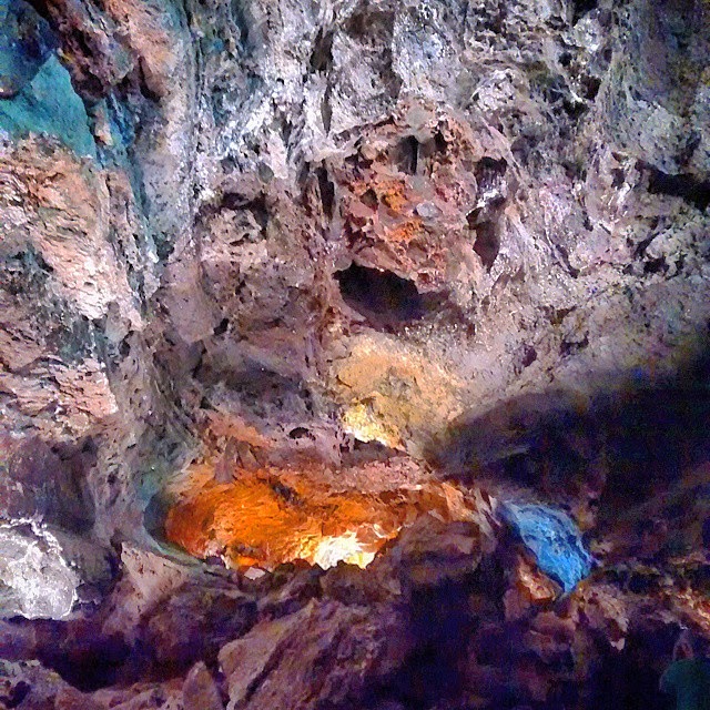


Two local artists were asked to help building the cave’s sound - and lightning system. They both did an amazing job subtly highlighting the most interesting areas but still being respectful of the surroundings making the interventions blend in perfectly.


La Cueva de los Verdes is open daily from 10am to 6pm. Try to get there early to avoid the crowd. The tour lasts about an hour and is given in Spanish and English and provides interesting and informative information about the lava tube. There are plenty of parking spaces available. You can find it on the road LZ-204 but there are plenty of signs to guide you to it. 

Sunday 30 November 2014

The Kite Festival of Fuerteventura

For 27 years every year a growing number of people gather on the island of Fuerteventura to celebrate the colourful three-day-long Kite Festival. As we had never seen one before we got on the ferry again, hired a car in Corralejo and drove down to see the famous kites.

The Festival is organised within the Corralejo National Park, amongst the sand dunes on Playa del Burro. We weren’t exactly sure where that was as the National Park is 7km long so we decided to just keep driving until we spot them. We didn’t have to wait for long and soon saw them flying in the sky.


In my mind I had the preconception that kites have a ‘kite’ shape and need people to skilfully keep them up in the sky. Well, these ideas were very quickly ruined. These kites came in a huge variety of shapes and sizes and thanks to the constant wind they did not require a human hand to stay in the air, a bag filled with sand did the trick just as well.


We were absolutely enchanted by the colours and the diversity of these kites. We kept pointing out the ones we hadn’t noticed before and praised the creativity of some of the more innovative ones.


There was even a workshop set up where children could make their own kites. Here’s a little girl flying her newly acquired possession.


One of our favourites was definitely the giant octopus that dwarfed everything else around it.


The Festival is always organised on the weekend closest to the 8th of November and is free to attend for all. It’s a great opportunity to go to Fuerteventura and enjoy the coveted sun, sand and sea, peppered with colourful kites. 

Tuesday 25 November 2014

Fuerteventura - National Park of Corralejo

Fuerteventura is the most Eastern island of the Canary Islands therefore the closest to the coast of Africa. It’s has a volcanic origin and let’s be honest, there’s not much to be found on it. Still we gave it a good go and went to explore its secrets.

The part of the island we were most interested in was that long stretch of whiteness that on clear days can even be seen from our ‘home’, Arrecife in Lanzarote. We took the ferry over, hired a couple of bikes and in a few minutes we were riding between the seemingly interminable white dunes of the National Park of Corralejo.

You are suddenly surrounded with a Sahara-like landscape and you cannot resist stopping and walking on this 7km long gorgeous golden sand. And when I say golden I mean the purest white soft sand that seem to melt and shape around your foot when you step on it. This quality is due to its organic origin as it is make up of broken shells and skeletons instead of the yellow sand blown over from Africa. Who would’ve thought that sharp volcanic rocks are hiding under the several meter thick blanket of sand?


To be honest we didn’t get too far as the sparkling turquoise water was calling us. We dumped our bikes and went straight for the sea. Here the water is so blue, so clear that you just have to go and run into it … and run out of it in the next second as the water is so cold!! The view is completed with the Isla de los Lobos and Lanzarote in the background.


If you can tear yourself away from the perfect combination of sea, sun, sand and the cooling breeze you can explore some more of the 24 km2 of the Park. A bit further up along the coast there are many smaller beaches and tiny coves waiting to be explored. Even during high season there’s a good chance that you can find a secluded spot if you feel like being away from the crowd.


Make sure you stop on the way to have a look at the dunes and take some spoof Sahara photos.


The PV–1 road that goes through the Park connects the two main port towns, Corralejo and Puerto Rosario. There are plenty of parking available on the side of the road and there are a few parking lots in the vicinity of the most popular areas.

Just a word of warning: make sure that you don’t park your car in the sand as the wheels can easily get stuck! Also, be advised that there is no lifeguard service on some of the beaches so swimming is at your own risk.

Wednesday 5 November 2014

Lanzarote – Caletón Blanco

Part of the ‘Off the beaten track Lanzarote’ series.

Up on the top of the island there´s a gorgeous strip of shore between Puerta Mujer and Órzola that are just simply a pleasure to look at. Due to the volcanic activity that dominated Lanzarote not so long ago the lava played an important part in shaping the topography of the area and this is especially true to this area. The lava that flowed into the sea has been attacked by the elements and created a long stretch of natural pools. There are numerous secluded sandy little coves to explore for the solidary types and there are also a few notable beaches to check out. The largest and most famous of these is Caletón Blanco.


We found the sign marking the parking area for the beach easily and slipped our tiny Fiat 500 amongst the seemingly giant Spanish family cars. The good thing is that the car park is right on the beach.

We walked a few meters and looked around appraisingly. Along the black volcanic rock the whiteness of the sand seemed striking and the turquoise blue of the water was utterly tantalising. We dropped our stuff in one of the thoughtfully erected, moon shaped wind shelters and ran into the water.


During low tide the water was VERY low, instead of a natural pool I would call it a natural paddling pool. Thanks to this the majority of the people here were families with small children. It is quite a sight to walk in the water as there´s sand under your feet and small fish dart around the water but you’re surrounded by black lava. It’s like swimming in a lava field!


Had it been formed closer South I am certain that this secret gem would be high upon the bog-standard tourist brochures’ lists. The beach of Caletón Blanco however up on the North and considering you have to drive a bit to get there it still manages to retain its local atmosphere. 

Monday 3 November 2014

Lanzarote – Timanfaya National Park

While in most of the national parks people go to see strange and unique flowers, plants, precious landscapes or endangered species, here in Timanfaya you only see one thing: volcanoes. But what volcanoes! The whole of its 51 square kilometre surface is made up entirely of volcanic soil, there’s not a single blade of grass here (although you'd be hard pressed to find one anywhere else in the island, if I want to be honest). As I’m obsessed with volcanoes at the moment I was getting ready to feel in paradise while walking around them.

The National Park was born between 1730 and 1736 when a series of volcanic eruptions shook up Lanzarote, literally speaking. This is when most of the volcanoes appeared however the eruptions didn’t stop then. The last one recorded was in 1824! As a result the topography of the island was altered completely as quarter of Lanzarote got covered under thick black lava. The last eruption of this volcanic activity is quite close in time, if you think about it, so nature hasn’t had a chance to start to take over. Let’s face it, the plants have to struggle seriously to push their roots into the hard lava rock.


Nowadays the only active volcano remaining is Timanfaya itself, the one that gave its name to the National Park. Where else would be the best place to build a visitor centre than right on top of that? It might seem crazy (in my opinion you can’t get any crazier than that!) but that’s exactly what happened here. Together with the Park’s devil symbol, which was designed by Lanzarote’s celebrity local artist, Cézar Manrique.

Volcanic activity is still very much present, in fact just a few meters under the surface it is already between 100 – 600 degrees. This is demonstrated to the curious visitor in a number of ways. An attendant pours water into the ground which in a few seconds shoots out as a geyser of steam.


Some dry scrub is dumped into a hole and in seconds it all goes up in flames.


In the restaurant you can buy chicken barbecued over the heat of the volcano.


And everybody goes on about their business like nothing is amiss. Crazy people, these Spanish.

Unfortunately the visits around the National Park itself is strictly limited and you are not allowed to drive around or set foot on it. The only way to see a fraction of the area is to being dumped together with hordes of other pasty skinned sweaty tourists on an old, hot bus and listen to the commentary in three different languages. We found the whole experience rather disappointing as we really don’t like being treated like cattle. Still, the park itself is absolutely stunning.


There is one way to hike in the park and it is to book a place with a guide. This activity is offered free by the Park however it has to be reserved in advance on this site (set the language at the top right corner). As only 8 people can attend one time and the earliest you can book is two months is advance it is quite a challenge to find free spaces therefore so far we haven’t had any luck. I’ll keep trying though.


If you’d like to visit the park there’s all the information you might need on this website.

Monday 27 October 2014

Lanzarote – Caldera Blanca volcano


Another weekend, another volcano. As we were in the vicinity visiting the Timanfaya National Park where you are not allowed to climb the volcanoes, Caldera Blanca seemed like an ideal option to satisfy our crater-watching needs.

Even though it looked close on the map it actually took us some time to get there as we had to go around it. From the village of Mancha Blanca we took a road towards it that soon turned into a dirt road. Our hired little Fiat 500 did not cope very well! When we found the path leading left we parked our little car on the side and continued our journey on foot. 


Caldera Blanca or ‘White Crater’ (458m) has the widest crater amongst all the volcanoes on the island (1200m across) therefore it’s a very imposing sight. It has two shorter neighbours flanking it from the sides, Montaña Calderata and Risco Quebrado. The three of them make up a so called island as during the eruptions of the Timanfaya volcano at the beginning of the 18th century lava flowed around them. 


The rocks that Caldera Blanca is made of are much older than the lava and it seems white in the sea of black, hence the name. In the vicinity there are some more, smaller areas that avoided the lava flow which, according to the information board we found, are ‘full of life’. Well…


After about half an hour walking we got to the foot of the volcano. The route leads up to the crater diagonally therefore it’s a nice, gentle climb, although you have to look where you put your feet.


When you get up to the rim the path is not that obvious although thoughtful people have placed a few cairns to guide you. At the end we just took the trail that seemed easier to climb. It gets a bit steeper as you advance towards the short pole marking the highest point.


Looking down into the crater of Caldera Blanca will take your breath away. It’s enormous! Its wall is very steep and thanks to this everything inside looks undisturbed by human activities. In the middle there’s a small patch where some plants seemed to eke out a living by gathering the rain that makes its way down the crater.


Due to the height you’re standing at you can take in the whiteness of the volcano, the blackness of the surrounding lava, the blue of the sea and the white of the small villages dotted around in the distance. Not to mention the volcanoes of Timanfaya National Park on the other side! From here you get an unobstructed, 360 degrees view of the island.


It is possible to walk around the rim however we were there late in the afternoon so we made our way down cautiously. Even though the ascent is not much and the climb is mostly manageable I would rate this walk to be moderate due to the trail leading down. It is full of small loose rocks and you have to be very careful not to slip. It took us much longer to get down than go up.

Make sure you bring your ‘volcano climbing kit’ which should consist of plenty of water and sun cream plus hiking shoes with good grip.

This walk can be done from many directions, most websites suggest walking from Mancha Blanca, from the North. We drove a bit closer and approached it from the West. It’s a great little hike as it doesn’t take long to do, rewards you with great views and you don’t have to go too far out of the tourist zone. Having said that no need to be worried about meeting many people up here, the majority of Lanzarote’s tourists prefer the beach.